
Real-time collaboration for
coordinated emergency response.
Built for the professionals who coordinate when it matters most.
A secure, web-based platform that unifies maps, reports, and communication into a single operational view.
Designed to adapt to the workflows, data, and operational needs of each organization.
Recognized Through the Comcast RISE Grant
Spin out of


One shared view. Faster coordination. Better decisions.
When multiple teams respond to the same situation, clarity becomes everything.
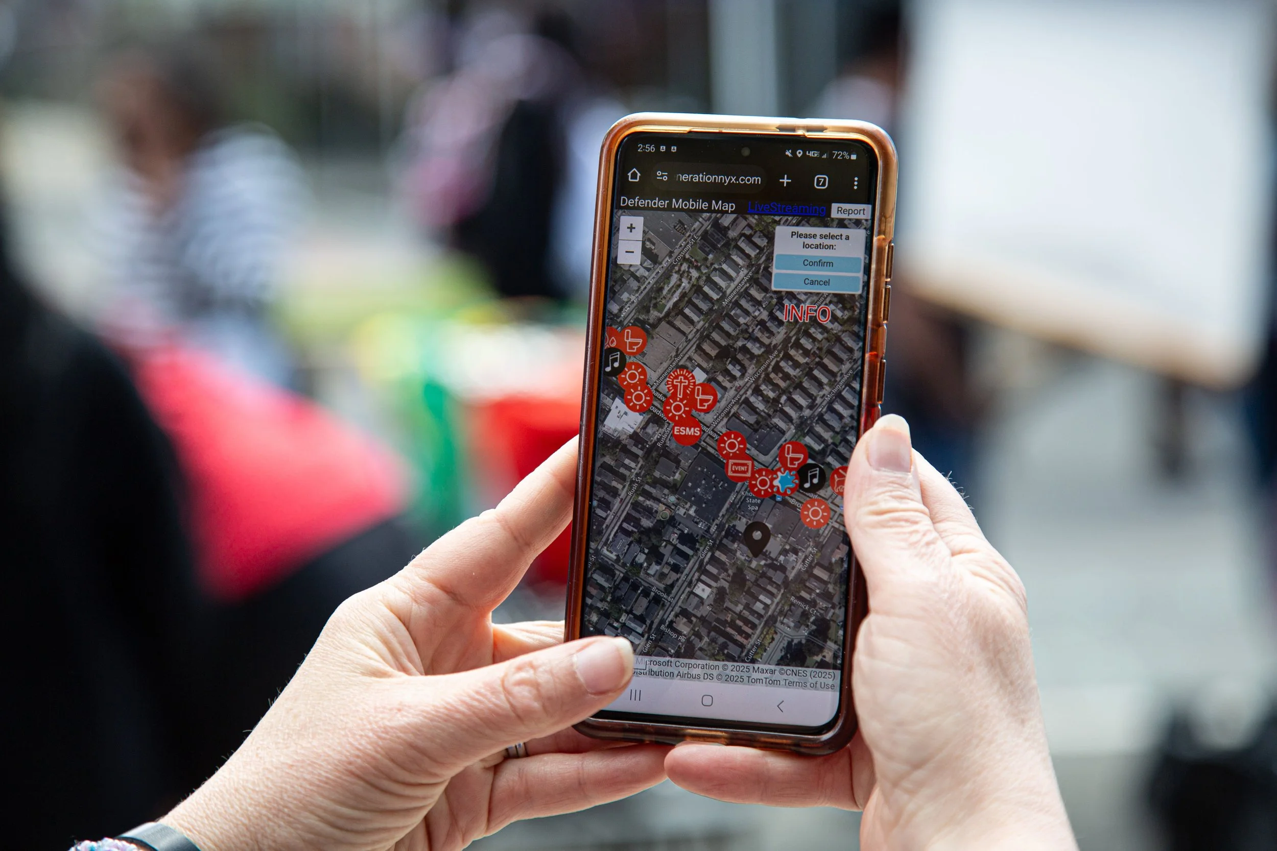
NYX Defender brings maps, updates, and communication into one shared view so teams can stay aligned, reduce confusion, and move forward with confidence.
NYX Defender can be customized to your needs.
MIT Lincoln Laboratory highlights Generation NYX in advancing crisis management.
How We Support Coordination
1) REAL TIME AWARENESS
A shared live map where everyone sees the same updates at the same time.
3)MULTI-AGENCY COLLABORATION
Secure shared workspaces where agencies can coordinate decisions in real time.
4) DATA INTEROPERABILITY
Designed to integrate with the systems agencies already use.
2) FIELD RESPONDER INTEGRATION
Field reporting, location tracking, and live video from phones and drones
Used by both professionals and volunteers—Designed for real-world urgency.
Built for those who act fast — connecting teams when seconds matter.
Empowering every responder — from local efforts to global missions.
Used by both professionals and volunteers—Designed for real-world urgency. Built for those who act fast — connecting teams when seconds matter. Empowering every responder — from local efforts to global missions.
Interactive
incident map
GIS overlays
(weather, hazards)

Secure team communication

Real-time team tracking
Live alerts & reports

Mobile & Field Access

Your operation is unique.
Your work involves: Different agencies, workflows, goals and priorities.
The supporting tools cannot be rigid. They must adapt to the way your team actually works.
Generation NYX Integrates external systems, standardizing unique data sets and tailoring features to align with standard operating procedures
Built for real-world responders and operations.

Public Safety & Emergency Response
Local and State Emergency Management Agencies
Fire & Rescue Teams
Police Departments
Medical Response Units

Institutions & Facilities
University Safety & Campus Operations
Indoor Event Venues

Planned Events & Coordination
Large Outdoor Festivals
Marathons & Parades
Stadium Events
Conferences & Trade Shows
Community Gatherings

Volunteer & Civil Response Teams
Local Emergency Response Teams
NGOs
Humanitarian Logistics Coordination